Charyn Canyon cuts a 154-kilometer fissure through the semi-arid steppe of southeastern Kazakhstan. Twelve million years of wind and water erosion have carved its red sandstone into 300-meter-deep gorges and towering rock pillars.
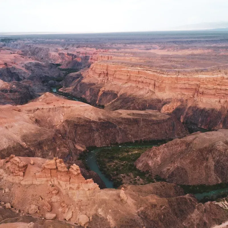
Charyn Canyon cuts a 154-kilometer fissure through the semi-arid steppe of southeastern Kazakhstan. Twelve million years of wind and water erosion have carved its red sandstone into 300-meter-deep gorges and towering rock pillars. The canyon floor sits at an elevation of 1,100 meters, creating a sunken world completely hidden from the flat plains above. You can drive within 50 meters of the rim and see nothing but flat scrubland until the earth suddenly drops away. The Charyn River runs along the bottom, fed by glacial meltwater from the northern Tien Shan mountains. Visitors walk through a dry, dusty landscape where temperatures swing wildly. Summer heat routinely exceeds 40°C, baking the exposed rock and turning the canyon floor into a natural oven.
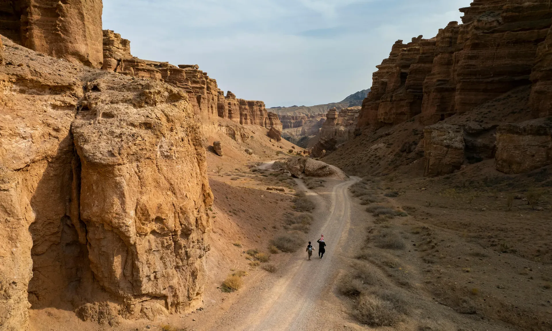
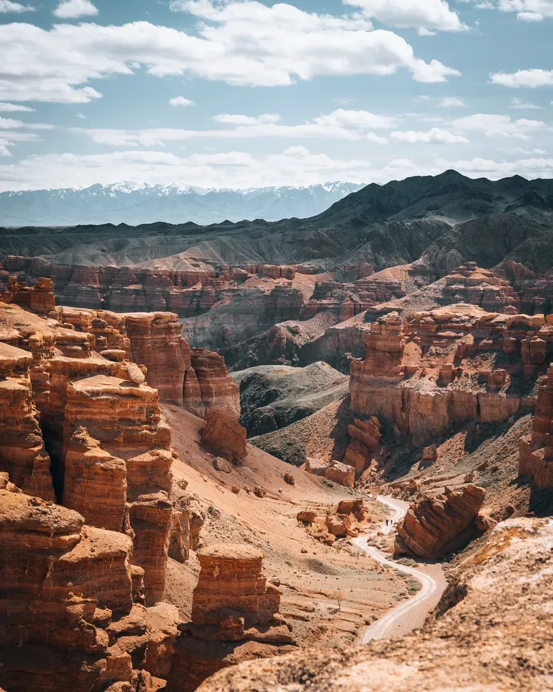
Five distinct gorges make up the massive geological system. The Valley of Castles draws the highest foot traffic and features the most dramatic vertical drops. Here, wind and water have eroded the sandstone into vertical pillars resembling medieval watchtowers. You descend a steep, unpaved track to reach the canyon floor. Fine red dust coats your boots within minutes. The towering walls block the prevailing winds, causing the air to stagnate along the 3-kilometer trail. Shadows shift across the rock faces throughout the day, changing the stone from pale orange at noon to deep crimson by dusk.
Mobile service drops completely once you step past the rim. You must carry all your drinking water, as the river water requires heavy filtration to be safe. Flash floods present a severe risk during sudden rainstorms, turning narrow corridors into fast-moving rivers of mud. Check the weather forecast in Almaty before driving the 200 kilometers east along the Kuldjin highway. The park gates open at dawn. Arriving before 10:00 AM lets you secure a parking spot and hike the trail before the large commercial tour buses arrive from the city.
The Neogene period laid the foundation for Charyn Canyon 12 million years ago. Volcanic activity and shifting tectonic plates pushed the Tien Shan mountains upward, altering the flow of ancient rivers across the Eurasian continent. The Charyn River began carving through the semi-arid plateau, stripping away softer topsoil to expose dense layers of sedimentary rock. Wind joined the water, blasting sand against the exposed cliffs over millennia. This dual erosion process sculpted the sharp, vertical pillars visible today. The exposed rock strata reveal millions of years of climatic shifts, alternating between deep red sandstone, grey gravels, and darker volcanic deposits. The canyon deepened by roughly one millimeter per year, eventually reaching its current maximum depth of 300 meters.
A massive glaciation event wiped out most broadleaf forests across Central Asia during the Pleistocene epoch. The deep, sheltered gorges of the Charyn River provided a unique microclimate that protected a specific species of tree from the advancing ice. The Sogdian Ash survived the deep freeze here. This five-million-year-old relic forest now stretches along a narrow 20-kilometer band of the riverbank. Only one other grove like it exists globally, located in North America. The dense canopy offers a sudden, sharp drop in temperature compared to the surrounding desert. Botanists discovered that the root systems of these trees have adapted to grip the sheer rock walls, drawing moisture directly from the river's spray.
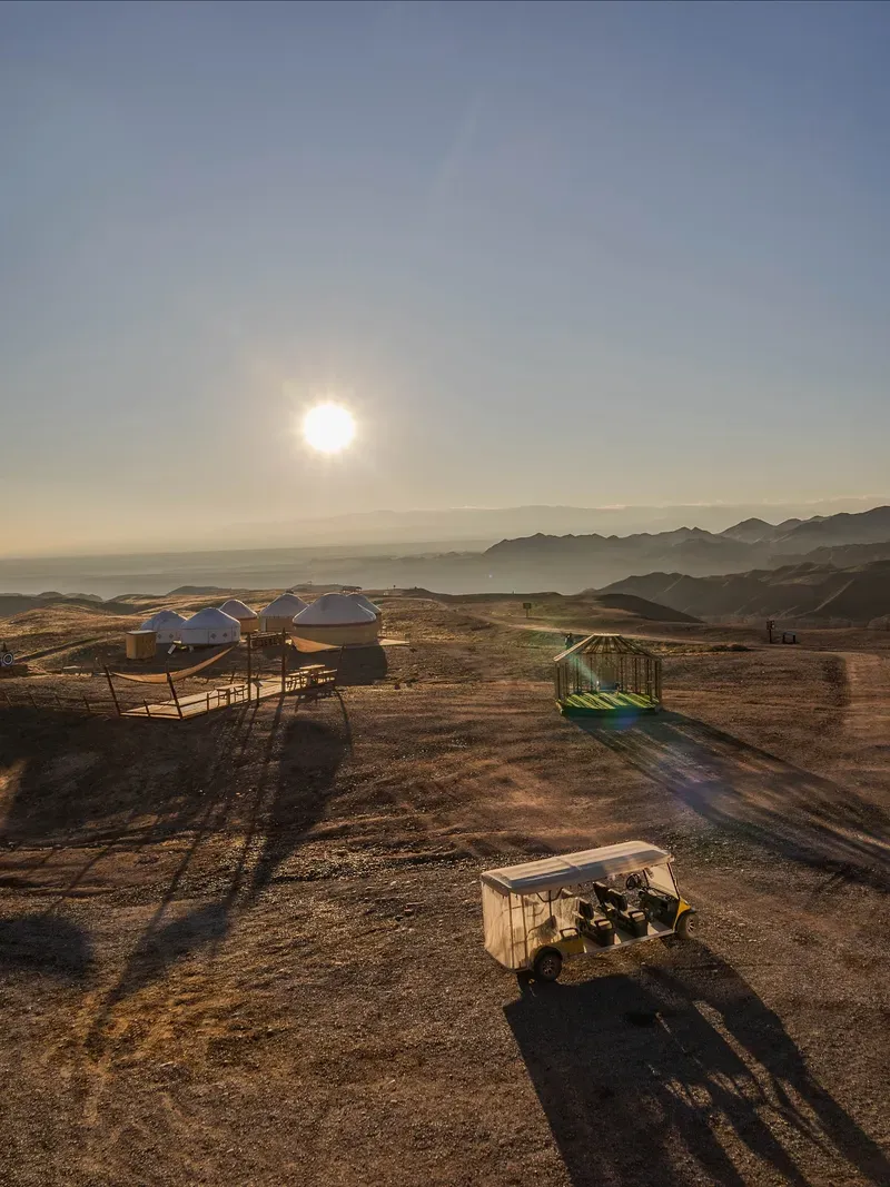
The Kazakh government established Charyn National Park on February 23, 2004. The protected zone covers 127,050 hectares of steppe, canyon, and river ecosystems. Early infrastructure consisted of a single dirt track, a wooden toll booth, and a few hand-painted signs. Tourism remained strictly local for the first decade, with Almaty residents visiting primarily on summer weekends. International visitors began arriving in larger numbers as Kazakhstan developed its transit infrastructure. The park recorded 117,000 visitors in 2024, a sevenfold increase from 2020. This massive surge prompted the installation of basic drop toilets, designated camping zones, and a fleet of modified off-road vehicles that operate as eco-taxis.
Increased foot traffic brings rapid degradation to the fragile sandstone environment. Visitors climbing off-trail accelerate erosion, crumbling the ancient pillars under heavy hiking boots. The park administration instituted strict rules against removing geological samples or disturbing the 1,500 plant species native to the gorge. Rangers actively patrol the Valley of Castles to prevent tourists from swimming in the Charyn River, where strong undercurrents drag swimmers against submerged rocks. Bring physical Kazakh Tenge to pay the 1,500 KZT entrance fee, as the remote gates lack reliable card terminals or internet access for digital transfers.
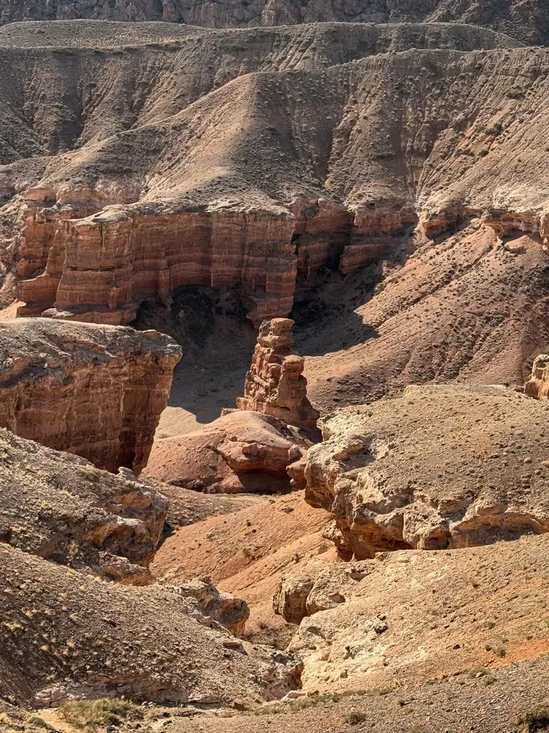
Charyn Canyon stretches 154 kilometers across the steppe and plunges up to 300 meters deep. The system comprises five distinct zones: the Valley of Castles, Temirlik Canyon, Yellow Canyon, Red Canyon, and Bestamak Canyon. The Valley of Castles features two kilometers of concentrated, vertical erosion. Basalt and sedimentary rock towers rise 80 to 100 meters above the dry riverbed. The iron-rich soil oxidizes in the sun, giving the walls a rust-red hue that intensifies dramatically at sunset. The rock is highly friable. Running a hand along the canyon wall dislodges a shower of fine sand. The path through this section is wide and flat, composed of packed dirt and loose gravel that shifts underfoot.
Temirlik Canyon presents a stark contrast to the arid main gorge. This branch, often called the Iron Canyon, harbors dense vegetation fed by a smaller tributary stream. The rock walls here narrow significantly, blocking direct sunlight for most of the day. A thick canopy of willow, poplar, and barberry bushes grows directly out of the rocky floor. The temperature drops by as much as 10°C the moment you step under the trees. Steppe ribbon snakes frequently hunt in the tall grass near the water, while golden eagles nest in the inaccessible crevices high above. The air smells sharply of wild sage and damp earth.
Yellow Canyon, also known as Moon Canyon, lacks the sharp verticality of the Valley of Castles. The sedimentary layers here contain high concentrations of clay and yellow sandstone. Water erosion has smoothed these walls into rounded, undulating hills that resemble a lunar landscape. Deep ravines cut through the yellow clay, creating a maze of dead-end corridors. Hiking here requires navigating steep, slippery slopes where the loose clay offers zero traction. Bestamak Canyon bridges the gap between the red and yellow zones, featuring alternating bands of colored rock that compress into a narrow gorge just wide enough for a single vehicle.
The Charyn River flows fast and cold at the base of the entire system. Meltwater from the Tien Shan mountains feeds the current, keeping the water temperature near 10°C even in mid-summer. The riverbed consists of smooth, water-polished stones that create treacherous footing. Swimming is strictly discouraged due to the rapid flow and hidden debris. You can hire an open-air eco-taxi near the water for 500 KZT to drive you back up the 3-kilometer dirt track to the rim. The ride takes ten minutes and saves you from a brutal uphill climb in the afternoon heat.
Local nomadic tribes historically avoided the deep gorges of the Charyn River. The howling winds funneling through the rock pillars generated sounds that early inhabitants attributed to malevolent spirits. The Valley of Castles earned the moniker "Gorge of Witches" among local herders. They believed the towering rock formations were demons turned to stone, waiting to trap travelers who wandered too close to the edge. This folklore kept the canyon largely untouched by human settlement for centuries. Nomads preferred to graze their livestock on the flat, open steppe where they could spot predators from miles away.
The Sogdian Ash grove provides a living link to the pre-Ice Age landscape of Central Asia. Botanists and researchers from around the globe travel to the park specifically to study this five-million-year-old relic species. The grove is now protected under UNESCO aegis, highlighting its status as a global biological monument. Kazakh universities regularly send geology and biology students to the canyon to conduct field research on the unique microclimates existing within the different gorges.
Today, the canyon functions as a primary driver for rural employment in the Kegen district. Local residents operate the eco-taxis, manage the small seasonal restaurant, and guide private 4x4 tours. The influx of 117,000 visitors in 2024 shifted the regional economy from pure agriculture toward ecotourism. Guesthouses and small cafes have opened in the nearby villages of Saty and Kegen to service the daily convoy of tour buses arriving from Almaty. Visitors must carry original passports at all times, as the park sits within a sensitive border zone shared with China. Military checkpoints occasionally pop up along the Kuldjin highway, and soldiers will turn back anyone lacking proper identification.
The canyon took 12 million years to form through continuous wind and water erosion.
The Sogdian Ash grove survived the Pleistocene glaciation and is one of only two such forests left on Earth.
Steppe eagles and golden eagles nest high in the inaccessible crevices of the vertical canyon walls.
Temperatures on the canyon floor routinely exceed 40°C in July, acting as a solar oven.
The main hiking trail spans exactly 3 kilometers from the rim descent down to the Charyn River.
You need a physical passport to visit because the canyon sits in a restricted military zone near China.
Modified off-road vans shuttle hikers up the steep 300-meter incline for 500 KZT.
The drive covers 200 kilometers and takes between 3 to 4 hours. You follow the Kuldjin highway toward Kegen. The final 10 kilometers consist of a mixed paved and dirt road leading to the park entrance.
Standard sedans can easily reach the main parking lot at the Valley of Castles. The road is fully paved until the final stretch, which is flat dirt. You only need a 4x4 if you plan to drive down into the canyon itself.
Cell reception is spotty at the parking lot and completely disappears once you descend into the gorge. Download offline maps before leaving Almaty. Do not rely on digital payment methods at the gate.
The entrance fee ranges from 730 KZT to 1,500 KZT per person. You must pay in cash at the ranger booth. Additional fees apply if you want to camp or drive your own vehicle down the canyon track.
Park rangers strongly discourage swimming. The river is fed by mountain meltwater, making it freezing cold even in summer. Fast currents and submerged rocks pose severe drowning hazards.
Group bus tours depart daily from Almaty city center, costing between $30 and $70 USD. These trips take 10 to 14 hours and often include stops at Kolsai and Kaindy Lakes. Private jeep tours run closer to 100,000 KZT.
April through June and September through October provide the best conditions. July and August bring extreme desert heat exceeding 40°C. Winter visits mean sub-zero temperatures and dangerously icy trails.
Basic drop toilets are located at the main parking lot and near the river. A small restaurant operates at the eco-park during the high season. Bring your own food and at least 3 liters of water per person.
The 3-kilometer Valley of Castles trail is wide and relatively flat at the bottom, making it suitable for active seniors and children over four. An eco-taxi shuttle is available for 500 KZT to skip the steep climb back to the rim.
Drone flights require official registration with the Aviation Administration of Kazakhstan. The park is located in a sensitive border zone near China. Unauthorized drone use can result in confiscation by military patrols.
Browse verified tours with free cancellation and instant confirmation.
Find Tours